Geographical Sciences · University of Maryland

Spatial methods for systems that change over time.

I’m Robyn H. Gausman-Burnett. I develop spatial methods for systems where providers, capacity, and residential geography interact, then translate them into location-based analysis for policy and program decisions. Education is the policy-rich setting for much of my current work; the methods are designed to extend to other place-based services, including public services and disaster recovery.

RESEARCH FIELD NOTESPLACE · PROVIDERS · CHANGE
ONE PLACEMANY TIES
Residential places · service providersConceptual illustration
University profile

Research in practice

Applied research · CEPEducation policy

Gifted education: identification, services, and state regulations

A national look at how policy defines giftedness and how students are identified and served.

Before CEP’s involvement, I reviewed gifted-education regulations and research categories to map how policies define giftedness, identify students, and organize services. I then proposed a participatory mapping project to the Center for Educational Progress and designed and built the source-verified comparative framework and database across 51 jurisdictions. The work includes state-to-state comparisons, under-identification diagnostics, data quality checks, visualizations, and documentation of measures and assumptions.

Role: Senior Researcher

Definitions & eligibilityAssessment & identificationServices & policy variation
Independent analysisU.S. Census Bureau F-33 · FY2014–2024

School-system reports of state gifted education aid

A state-level view of separately reported gifted aid, with survey reporting gaps made visible.

How much state-source funding do school systems separately identify for gifted and talented programs—and how much of the picture is shaped by survey coverage and reporting practices?

$1.62BSeparately reported in FY2024
18 / 51Jurisdictions with positive reported aid
87%Of the reported total from Georgia and Florida

This school-system survey is not a complete measure of state funding. Reported zero and missing are distinct data conditions; neither establishes that services are absent.

Explore the full finance analysis

Selected research

Ph.D. advisor: Laixiang Sun

My research addresses an under-specified methods problem in geographical science: comparing public-service geographies longitudinally as provider sets, capacity, and governing rules change. A fine-grained spatial lattice keeps residential support constant for those comparisons; related work develops interpretable measures for censored administrative data.

Working paper

Deterministic Mamdani fuzzy inference for privacy-censored data

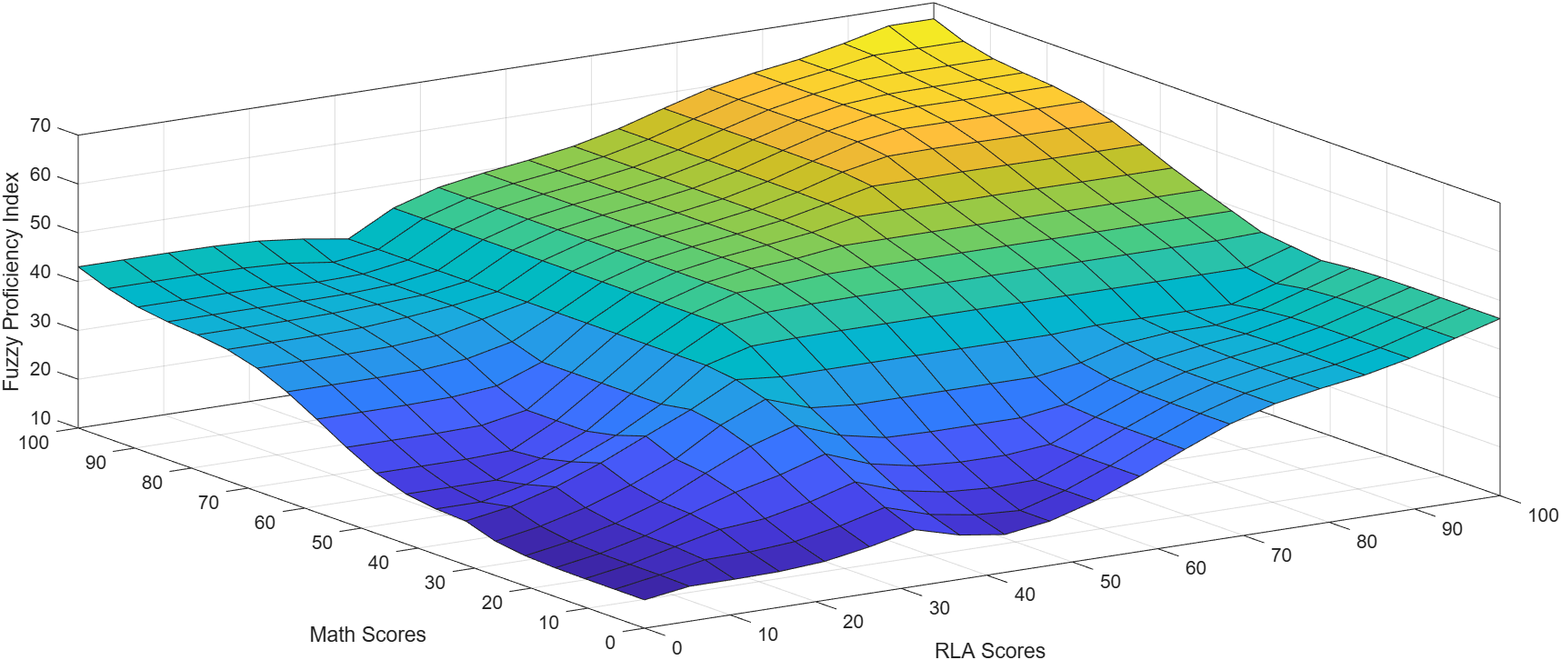
Develops a deterministic approach for transforming exact, interval, and threshold reports into interpretable measures without probabilistic imputation. The paper examines interval encoding and benchmark calibration using school proficiency data.

Fuzzy Proficiency Index surface over Math Scores and RLA Scores, showing the output of the Mamdani fuzzy inference system across input combinations.
The model maps Math and RLA scores to a continuous proficiency index.
Request a copy
Dissertation researchMissouri and Milwaukee applications

Dynamic service geographies on a fixed spatial lattice

Develops a reusable framework for representing relationships between residential places and service providers on a fixed spatial support as providers and capacity change. Missouri and Milwaukee school systems are the empirical applications. The framework is designed to extend to other place-based services, including public services and disaster recovery.

Conceptual comparison over two time points. Hard assignment links the same residential block to provider A at both times and records no change. Relational membership retains links to providers A and B at the first time point and A, B, and C at the second, revealing a change in provider set and internal structure.
Conceptual illustration; links represent modeled affiliations, not observed assignments.
View the full Models 1–3 architecture

Ongoing dissertation work · Ph.D. in Geographical Sciences, University of Maryland

Applied policy analysisMilwaukee, Wisconsin

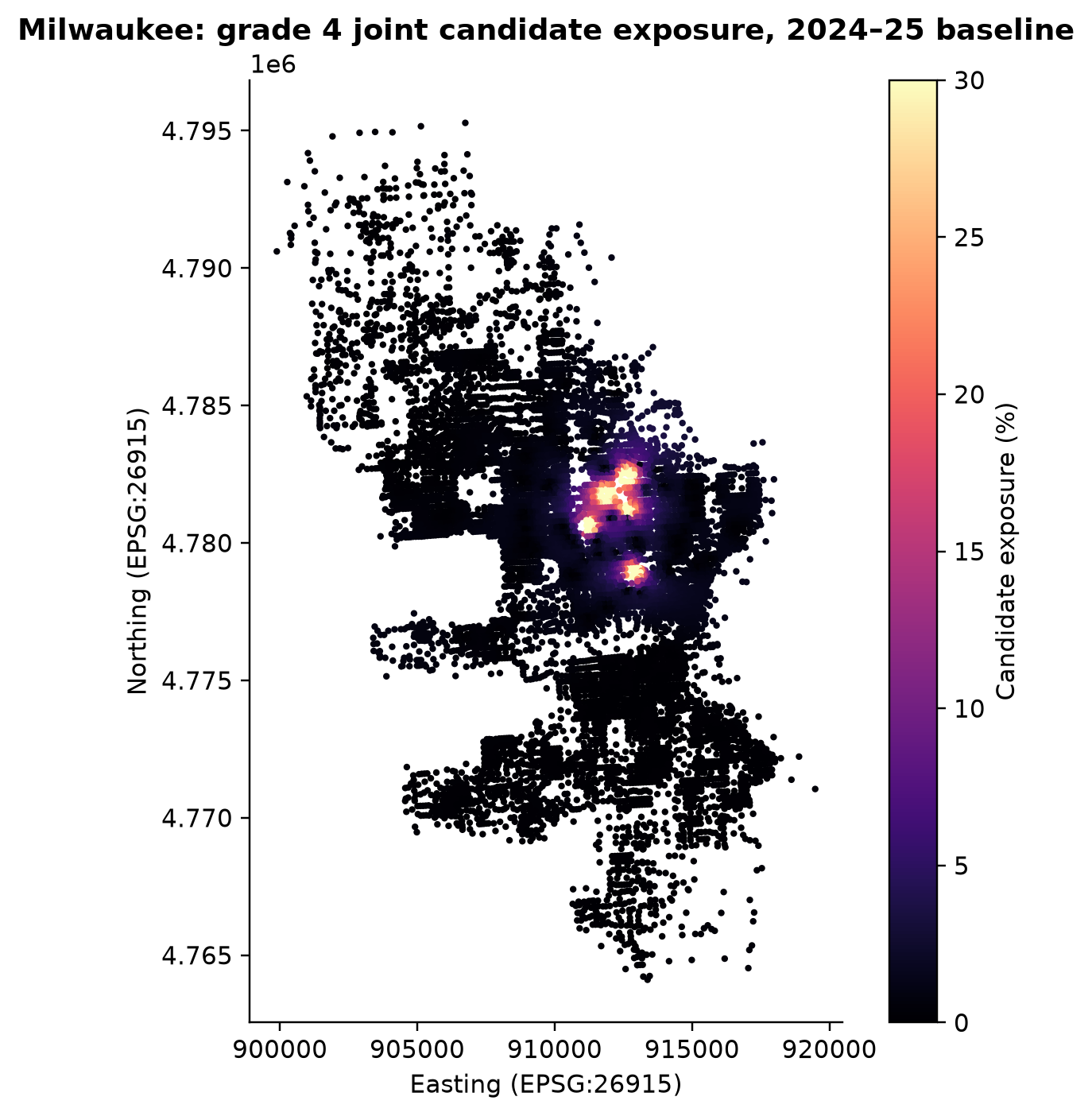
Neighborhood exposure to school closures

Maps how modeled neighborhood affiliation to schools is distributed before a closure and compares the receiving-sector mix under alternative routing assumptions. The analysis is designed as a planning measure, not a forecast of student transfers.

Milwaukee map of modeled grade 4 joint candidate exposure for the 2024–25 baseline, with higher exposure shown in brighter colors.
A planning measure under the stated routing assumptions, not observed student transfers.
Ask about this project
Wolfram Summer School 2025Wolfram Community Staff Pick

No Child’s Land: Where Opportunity Falls Off the Map

A Wolfram Language project on the geography of opportunity, presented through Wolfram Summer School. The Wolfram Community selected the project as a Staff Pick.

View the Wolfram project

Analysis informed by practice.

Before doctoral study, I spent more than fifteen years in K–12 teaching and administration in the United States and abroad. That experience continues to shape the policy questions behind my research.

Current

Ph.D. candidate, Department of Geographical Sciences
University of Maryland, College Park

Previous education

M.S. Economics, The New School
B.S. Economics, Villanova University

Teaching & administration

UMD (2023–present): Lecturer, GEOG 306 and GEOG 212; TA, GEOG 140; undergraduate advisor. K–12: Curriculum/Technology Administrator, Mysa School (2019–2023); Curriculum Specialist and Faculty, Maryknoll School (2017–2019); earlier classroom teaching and school administration in the United States and abroad.

Technical skills

MATLAB · Wolfram Language (Mathematica) · Python · R · GIS · Spatial modeling · Data visualization

Earlier writing, still in conversation with the work.

My older WordPress site collects essays and reflections on human geography, education, and economics, alongside writing from my years in schools.

Visit the WordPress archive

For project, research, and policy inquiries

University of Maryland · Geographical Sciences